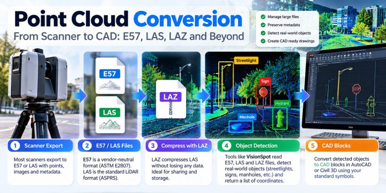
A point cloud rarely arrives as one tidy file you can open and use. It travels through a chain of formats, and each hand-off is a place where size balloons, metadata goes missing or a coordinate system quietly disappears. Here’s the usual route from scanner to CAD, stage by stage.
Stage 1: the scanner export
Most scanners and processing packages export to E57 or LAS. E57 is a vendor-neutral format standardised by ASTM (E2807) that can carry points together with images and metadata. LAS is the long-standing binary format for LiDAR data, maintained by ASPRS. Both can run to many gigabytes for a single site. Exports usually come with options for precision, colour, intensity and scanner positions. Choose them deliberately, because anything left out at this stage can’t be recovered later.
Stage 2: compression with LAZ
LAZ is LAS compressed without losing any data. It’s the format you send when email or an upload form won’t take the original. Because the compression is lossless, unpacking it returns exactly the same points.
Stage 3: from points to a list of objects
Here the point cloud stops being just geometry. A detection tool scans it for known object types and returns a list: this lamp post here, that drain there.
VisionSpot, an ML-based tool for surveying, does this step. It reads E57, LAS and LAZ files from 500 MB up to 100 GB, and its web version returns the detected objects as a text document. Today it finds streetlights, road signs, utility poles, manhole covers, storm drains, trash cans and fire hydrants.
Stage 4: CAD blocks
A list of coordinates isn’t a drawing. The last conversion turns each confirmed detection into a block in the CAD environment, using the symbols the client expects. VisionSpot’s plugin for AutoCAD and Civil 3D does this with a library for your topographic format, so the blocks match your standard from the first run. Check one block against the point cloud before you accept the whole batch.
Picking a format for the hand-off
A simple rule of thumb: store and send in LAZ to save space, switch to E57 when images and scanner positions matter, and keep LAS for software that expects it. The detected-object list is a useful middle step too, small enough to review quickly and structured enough to convert in bulk.
Whatever you choose, write it into the project notes. The person who opens the file in a year won’t remember which export settings you used.
Where conversions go wrong
- Coordinates. Make sure the coordinate system is recorded with the file or documented next to it. A drawing in local coordinates and a cloud in a projected system won’t line up by accident.
- Size. A format change on a very large file is where jobs stall. Test the pipeline on one file before you run it on twenty.
- Silent loss. If a conversion drops intensity, colour or classification, you may not notice until someone needs them.
- Review. Detection output still needs a person to accept or reject items before they reach the drawing.
A quick test before you commit
Ask any vendor two things: which formats it reads, and whether you can run a sample first. For VisionSpot the second answer is yes. Send a file, and the team configures the tool to your drafting standards and returns the results free of charge.